
 Up for review today is the Suunto X10m, an improved version of the X9i I reviewed in 2007. It’s a GPS watch with a long list of features that belie its understated appearance:
- GPS: Routes, waypoints, tracks, speed distance, 1 meter (3ft) resolution.
- Plan and visualize tracks on a PC ahead of time, then download to the watch.
- Google Earth compatible (screenshots and more below).
- Altimeter: Altitude, vertical speed, alarms for set altitudes and rates. Temperature compensated.
- Barometer: Absolute pressure, sea level pressure, trend graph, weather alarm.
- Integrated temperature sensor (which isn’t accurate unless the watch is worn outside your sleeve).
- Watch: 3 alarms, time optionally set via GPS, dual timezone support with 30-minute offsets supported.
- 100m (330ft) water resistant as long as you don’t press the buttons.
- Integrated lithium rechargeable battery, specced for 500 charge cycles, recharged via the included USB cable.
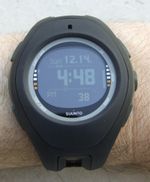
- Available in different colors as well as the supplied military version (all black, reverse LCD, red backlight, with support for the military grid coordinate system and ‘mils’ compass readings).
Full review continues below.
Compared to the X9, the X10 improves GPS sensitivity and better battery life (33%). Watch size, shape, and weight are unchanged.
The GPS memory can store up to 26,000 points at either 1 second or 1 minute intervals:
If you’re in 1-second mode, and using the watch intensively, expect six hours of battery life. At the other extreme, if you leave everything off and just read the time, it’ll last up to two months. Something to think about before going on a long hike; perhaps consider a small solar panel with USB connectors.
There are some cool uses of the X10 other than the obvious expeditionary stuff: did you know that, by using a GPS at the same time as your camera, you can automatically geotag your pictures after the fact? There’s free software that correlates the timestamp on the image with the GPS track data, and then tags the pictures with the estimated location. Given the very cool support for this in Flickr and iPhoto, the X10 is an excellent way to do so, and quite unobtrusive. (I wore the X9i to Buenos Aires, and no one took any notice at all.)
You can also use the Suunto Track Exporter software to download to Google Earth which is, I think, one of the best ways to use any GPS. Here’s a drive to Santa Margerita Ecological Reserve, followed by working on equipment in the base of the canyon:
(KMZ file is available here.)
And here’s an urban bicycle ride:
(KMZ file is available here.)
If you zoom in on the points, you can see the improved sensitivity in action. It still takes a few minutes to acquire the initial position, but after that the data is impressively accurate solarmovies. I also took it flying, but due to user error, all I have is pictures and no data.
It worked great in flight, easy to read and comfortable.The physical size and weight are unchanged from the X9: 76g, 54x18mm.
It also includes a strap extender, so you can easily wear it on the outside of a parka or bulky coat.
The X10 is rated from -20C to 60C (-5F to 140F), so this is quite feasible.
The compass can work without the GPS on, yielding an intermediate power consumption mode for hiking or where the GPS can’t get a signal (cities, dense forest, canyons, caves). The bearing lock is a great help in those situations.
To connect the X10 to your computer, there’s a spring-loaded USB cable with a jaw connector on one end and USB-A connector on the other. Once plugged in, the watch starts charging automatically and can talk to the supplied software. Note that there is no planned or extant Macintosh support, so you have to use an emulator to communicate.
Here’s a screenshot of the Suunto software, showing data from the bike ride above:
As you can see, the GPS data is plotted on a blank canvas. You have to purchase maps separately, so for casual use I recommend using Track Exporter and the free Google Earth instead.
These pictures show the cable and its mating pins on the back of the watch. You can also see a screw in the strap — according to Suunto, the strap is user-replaceable; a nice touch.
The caseback is smooth and contoured for a comfortable fit. The curvature of the strap and the 57mm size keep it firmly in place during strenuous activity.
The buttons are, as far as I can tell, the same as those on the X9i: Rubber coated, and requiring a too-firm press to activate. I had problems determining when I had pressed one, as the display can sometimes lag a bit. I’m hoping Suunto improves these in the next model. That being said, they work and seem durable.
Overall, the X10 is a nice set of improvements from the X9, and I like it. I’m not sure if I’d get the normal version or the reverse LCD X10m version pictured, but both are available online. I should note that Suunto PR kindly supplied this review unit, and were extremely patient with this long-delayed review, for which we thank them.
The X10m version is designed for military use, and has:
- Reverse LCD screen.
- Red LED backlight to preserve night vision.
- Support for mils compass measurements.
- Support for the military grid coordinate system.
- Non-reflective ion-plated black stainless steel on the strap.
The red LED is actually pretty cool, even for us civilians. See both in person before you decide.
You can learn more about the X10 at the Suunto campaign site that has movies, demos and example uses. It’s available now for around $500.
By Paul Hubbard